Day 17.1 – Wick

thumbnail imageHas it sunk in yet? No! What a day.

We were so anxious to get started we were both up before 6am packed and ready to roll at 7am! There had been a couple of sharp bursts of rain during the night but the morning was trying to be bright but with the niggly but not strong northerly breeze still.

We were headed east though so it didn’t bother us too much. We have been very very lucky with the weather. The last two days would be very tough with bad wind and/or rain. Our friend Sam who we shared a day with back in Devon had the wind so bad from Bettyhill it actually knocked him off of his bike and he had to push for a short stretch.

The A836 is wide, smooth and almost deserted. Great cycling road with views of the sea to our left. It’s hilly for the first 20 miles though. It climbs headlands between little sandy bays 4 or 5 times. Quite tiring but nothing really too bad or steep.

Before Thurso it flattens out with just one small climb before the descent into town. We didn’t linger and cycled straight through. According to the welcome sigh the only thing it’s famous for is being the birthplace of the founder of the Boy’s Brigade.

After Thurso it was just a case of getting the job done. We were on mileage countdown, each sign greeted in despair when it only indicated one more mile done when it felt more like three! The weather was getting sunnier and sunnier, we’d had two very brief bursts of rain during the ride. Too chilly to take off jackets though.

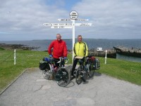
It’s a pretty flat easy run in and soon we could see the dilapitated hotel and we rode side by side down the slope to the finish line. A punch of the air and we’d done it!

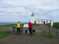
We got the required photo done with Andrew’s cycle computer mileage of 1071 miles which has been reading a little under. My Geko GPS reckons 1083 miles but who cares we’d done it! I’ll go through the GPS trace when I get home and get ‘official’ distance, ascents and average speeds.

After ringing home we had a coffee in the caf

Day 17 – John o’ Groats

thumbnail imageWe finished! Best feeling ever. OMG that was so ace! Hard morning but the sun is shining and life is FAB!!!

I’ll blog properly later. We need to cycle to Duncansby Head and to Wick this afternoon.

Distance : 50.13 miles
Time cycling : 4h39m
Ascent : 770 m
Average speed : 10.8 mph

Day 16 – Bettyhill

thumbnail imageNearly there! Just fifty miles between us and JOG.

Phew what a tough penultimate day. We were both exhausted as we got to Bettyhill.

The day dawned grey and overcast but still. Much much cooler too, definitely not a shorts day. We got away at 8am and stocked up on food in Evanton. We made steady progress across Easter Ross on the B9176 which was basically one long climb for many miles, a couple of descents knowing you would have to regain the lost altitude.

The hills were hidden in low cloud but we did glimpse the A9 bridge over the firth. The descent from the top was exhilirating. A smooth windy road which was so much fun.

By the way the NCN route alongside the B-road to Alness is nuts. Basically a rough path in the woods that crosses the road several times. Why would anyone choose to use it instead of the quiet road?

Anyway, the A836 to Bonar Bridge and Invershin was easy and quiet. To Lairg it’s a steady unsteep climb and descent. I expect the B-road NCN alternative has steeper gradients. We also saw the NCN cross the Kyle of Sutherland adjacent to the railway bridge via three flights of steps!

Lairg, the last bastion of civilisation north. We stopped for tea and cake.

The single-track A-road north was fun for about five miles. Flat, quiet and quite scenic. After about ten miles it started to get a little dull. After twenty miles we started to go a little crazy. By thirty miles we were talking to the rocks. By forty miles we’d had enough.

We felt a little sorry for the JOGLErs that past them, what a depressing way to start the journey south. Hour after hour of nothing.

You round a corner expecting something new and you’re faced with the road snaking into the distance for another few miles. Very desolate. Rocks and heather and heather and rocks. Great views and vistas though, very very quiet as well. We stopped for lunch beside the road at Crask. Two houses in the middle of nowhere. One of them a pub.

At the throbbing metropolis of Altnaharra we turned onto a B-road that looked identical to the A-road except it went alongside Loch Naver which added some interest. We bought ice creams at the most isolated Caravan Club site there must be. Looks like midge heaven staying there.

Onwards we plodded alongside the River Naver. We were getting weary. North of Syre the road becomes a little undulating too but more dwellings and farmland.

At last we got to Bettyhill and camping. Tired but happy to be on target to finish.

Tomorrow’s plan is to start early and try and finish at lunchtime. Get the necessaries done, relax a while. Then cycle out to Duncansby Head to get to the most extreme northeast point. Then onto Wick to camp for the train home on Thursday morning.

Exciting!

Distance : 77.46 miles
Time cycling : 7h11m
Ascent : 1075 m
Average speed : 10.8 mph

Day 15 – Evanton

thumbnail imageIt’s amazing what I forget to blog about. Like I never mentioned the occasion when a wasp flew into Andrew’s cycle helmet during the ascent to Tebay and busily set about stinging him on the head as he frantically tore his headgear off!

Or the second puncture I got yesterday. After cycling offroad for much of the day and many miles on a stony forest track where it was a miracle neither of us picked up at least a puncture. I then cycled onto the campsite in Fort Augustus and pssssssh, real wheel puncture from something or other on the driveway. At least I could fix it at leisure. Ho hum. Who was sponsoring me per puncture?!

Back to today. Funny old day really, a day of two halves.

It was already warm when we set off at 8.30am, definitely shorts weather. We had always planned to take the B-road route southeast of Loch Ness and avoid the potentially busy A82. We knew this route started with a big climb. It’s a big climb. A long climb. A fairly steep climb. A big long fairly steep climb on a hot morning. By halfway up the sweat was not dripping off but actually trickling off.

We had several false summits, 250m must surely be it, it can’t go higher than 300m as there’s no more land to go to. Four hundred metres and you reach the top. Fort Augustus is at 25m and the summit is only 5miles away.

By the way, on the way up we passed Loch Tarff which had the most amazing mirror-like reflections. Absolutely gorgeous.

The top has a viewpoint, and boy what a view. On top of the world. Worrh the effort just to sit there a while and take it in. The fact you got there using your own muscle power makes it so so much sweeter.

These early day climbs really take it out of the legs for the rest of the day though. We learnt this from Slaidburn. We still had the descent to Foyers to enjoy, which also had a couple of short steep ascents too.

During the descent Andrew’s 4th spoke snapped. This time on the cassette side so no chance of a repair even if we had a spare. No choice but to cycle on to Inverness. The rims are strong though and with loosened brakes it wasn’t too much bother.

We had a teabreak in Foyers and pushed on along the Loch Ness coastline. This stretch was lovely and shaded by trees. Made it a very pleasant flat ride with occasional fab views across the Loch. We saw the monster near Urquhart Castle on the opposite bank (see photos).

It wasn’t too long before we arrived in Inverness and a bike shop to do a reluctant repair. Maybe it’s a while since we’ve been in a city but we found Inverness unpleasant and unhelpful. We left the bike and walked into town for lunch, served by reluctant and unhelpful staff.

It took an hour and a half for the bike to be done. It turns out Andrew’s rear wheel has been fitted with cheap unbranded spokes despite the shop in Oxford saying otherwise. He’s not too happy with them.

We were glad to see the back of our last city before JOG especially as NCN 1 leaves it by the most unpleasant industrial route.

To leave we had to cross Kessock Bridge. We both agreed this was scary and the worst bit of the whole journey. Why? It has a cycle track. The track is separated from the traffic by a crash barrier and nothing else. It is less than 2m wide. The other side is a fence about 1.5m tall. Beyond the fence is a very long drop into nothing. And there was a crosswind. I have never gripped the handlebars so tight and willed it to be over. Trucks whizzing by inches from your elbow, the wind blowing you and the threat of a huge drop So scary. We both hated it.

Inverness really messed the day up, delays and rubbishness. The road along Beauly Firth was nice enough but we were pushing on. After that the roads were dull and fairly busy. Dingwall still has the maddest oneway system it had last time I was there.

We decided there was no hope of getting much further at a sensible time with no promise of a campsite after Alness for many miles. So we stopped at Evanton. A little short on distance and with a northerly breeze picking up tomorrow could be a long tough day.

We want to finish at a reasonable time on Wednesday so we’re getting an early start tomorrow to make sure we get to at least Bettyhill (about 68 miles) and hopefully a bit further than that. We’re stocking up on food before we set off as there isn’t much civilisation and it’ll save us time.

So I bid you good night and wish us luck for tomorrow.

Distance : 58.15 miles
Time cycling : 5h20m
Ascent : 1577 m
Average speed : 10.9 mph
Day 14 – Fort Augustus

thumbnail imagePhew what a scorcher. Boy have we been lucky with the weather? We’ve not had any appreciable rain since Devon. We had a little from Dumfries and bits of drizzle occasionally. The last few days have been unbelievable though. Today was very hot, no wind at all to notice and wall to wall sunshine. The tans are coming on nicely!

Mind you it made cycling pretty warm work at times, we were gulping through the Powerade at a rate of knots (the blue one is my fave BTW).

The first 25 miles to North Ballachulish were easy. The road was extremely quiet, smooth and pretty flat. We were setting a blistering pace. It offered great views across Loch Linhe too. We passed Castle Stalker which was used in the Monty Python film, The Holy Grail. We shared a few choice quotes and took some piccies.

We joined the A82 at North Ballachulish (can’t believe I’ve hust typed that twice using the tiny onscreen keyboard) which was busier but not unbearably so. A few nutter coach drivers that got a shake of the head occasionally. Motorbikes are pretty poor too, they never slow down and never leave much room, they seem to enjoy buzzing you at 80mph. Even ex-motorcyclist Andrew was scathing of their antics at one point.

We weren’t on it for long though and it’s nowhere near anything like the A40 or A420 back home which I wouldn’t cycle on.

By the time we got to Fort William we were averaging well over 13mph. We stopped at a bike shop to get Andrew’s back wheel looked at. He was worried about a ticking noise and a slight buckle from the spoke repairs. The young guy in the shop spent an hour rebuilding the wheel and straightening it and then only charged

Second Rest Day

thumbnail imageI call it a rest day when in actuality it was much more a washing and relaxing day. We’re both in good nick and would have been fine for cycling. No doubt a day off of the saddles and plenty of nourishment will do us no harm.

We were both up pretty early. We usually rise at 7am on cycling days and take about 90 minutes to breakfast, wash and pack up all the stuff on to the bikes. We are usually on the road between 8.30 and 9.15.

It was before 8.30am that we were walking next door to Tralee Bay Park to use their laundry facilities. It really helps to have friends who know people! We bumped into Richard as he was just off sailing and mentioned we were thinking of cycling up to the Sealife Sanctuary later. He gave us a couple of complimentary tickets which was rather decent of him!

We spent the next hour watching clothes washing and lugged it back to Seaview to hang out on the fence next to the tents. A ready made washing line! The breeze and warm sunshine made short work of doing the drying.

We then pottered about, did some bike bits. Read books etc. Until lunchtime when we walked into Benderloch and had a bite to eat at the excellent caf

Day 13 – Benderloch

thumbnail imageOur shortest day since Cornwall. Not entirely sure how that happened. I had 62 miles on the schedule but we did do a few of those yesterday and we have stopped a few miles short of Barcaldine. No matter, it was nice to finish a bit earlier for a change.

Cycling in Scotland is so easy. There is virtually no navigating to do. The hills are long but not steep. The A-roads we have been on are smooth and fast. They have also been very quiet, a few lorries and coaches but deserted for long periods.

Most drivers are very courteous, wait and leave plenty of room. Especially truck drivers. Coach drivers are a little less inclined to leave a good space. Worst drivers appear to be the much older ones, some are pretty poor at judging overtaking and for leaving room. Not had anything to be overly concerned about or worth getting agitated over though.

The morning was misty and there was a fine drizzle in the air as we packed up and set off. We used rear random flashing lights for only the second time as we headed for the dreaded Glen Croe climb.

Usually the thought of what’s ahead is much worse than the reality. The climb was continuous and steady. Never steep. This made it easy, no going up a bit, dropping some, having to regain the altitude again etc. Just drop into the lowest gear and pedal for 5 miles until you go into the clouds and reach the top admiring the awe-inspiring scenery as you go. We only stopped once and that was at a red traffic light at some temporary roadworks.

We pulled into Rest and be Thankful at the top and took a few piccies. Absolutely amazing cycling experience, I had a huge grin on my face. Ask me to cycle up that 12 months ago and I would have told you where to go!

Where there’s an up there has to be a down. Six (count them) miles of down with barely a pedal turned. Through the most breathtaking, jawdropping scenery imaginable. Find me another 11 miles of cycling like that.

This took us to the shore of Loch Fyne for a few miles of cycling in the opposite diection to JOG to Inveraray. Just before arriving Andrew broke his third spoke so we had a longer tea/coffee/cake break than usual as he used the last spare bought in Crediton. We were in such great moods from the fab cycling we didn’t even care.

The A819 north to Loch Awe was a mini Glen Croe. This road was very quiet, very little traffic. Five miles of steady up and five miles of steady down. We had the slightly odd view of our route ahead through the Pass of Brander being directly behind us for a few miles as we had to follow the shoreline around to get to it. We stopped for some lunch at Lochawe village.

The A85 through the pass was a little busier but the road is wide and easy cycling. Progress was very rapid. It wasn’t very long before we could see Connel Bridge ahead. We stopped to watch the falls as Loch Etive empties into the sea for a bit and got directions to camp from Red.

Just a few more miles to Benderloch and Seaview campsite. Which has the most powerful shower yet experienced. Now I know what cars in a jetwash feel like.

Thanks to Red (Martin) and his Dad Phil we were welcomed into Tralee Bay park next door for a fish supper, a sit down and a chat. We can use their laundry tomorrow too. Cheers guys for sorting us out and making us feel very welcome.

A pretty easy day all told. Either we are getting fitter or it’s getting easier! I need a safety pin to keep my trousers up in the evenings now BTW so the old weightloss program must still be working!

Second rest day tomorrow, everything in the wash again. Time to practice my Levi’s ad impression again…

Distance : 55.27 miles
Time cycling : 4h42m
Ascent : 1381 m
Average speed : 11.7 mph

Day 12 – Ardgarten

thumbnail imageBy far the easiest day’s cycling we’ve had. Flat (the ascent below is clearly wrong, I’ll need to check the data when I get home), fast and easy.

It’s amazing that we can now get on the bikes and knock out 70 miles and barely flinch!

We started in Troon and got a nice early start to cancel out the 10 miles we needed to do to get back on course. The A759 was about a billion times easier than going back over that stupid hill.

We were setting a blistering pace and averaged nearly 14mph getting to Kilmaurs and Fenwick.

The A77 has recently been replaced by the M77 and is now virtually deserted Not only that but it has an amazing segregated cycle track alongside. Although a gentle gradient upwards to start with the good surface allowed for rapid progress.

The descent through Newton Mearns and into Glasgow was fantastic. Definitely the way to enter the very cycle friendly city as we barely had to pedal for miles and miles!

We picked up the NCN 7 signs to get us across the Clyde via Bell Bridge. Not too bad a route despite it leading us to a fence across the road at one point. A small diversion and we were crossing the river.

Picking up the NCN route on the other side was much harder so we ended up on a road through an industrial area which had different smells at each business. Fascinating place. We got back on the less pleasant NCN route to Clydebank where we stopped for lunch. I really want to try deep fried pizza one day.

Argh. First puncture ever on my bike, not bad for over 2000 miles cycling. Front punctured by a thorn. Easy repair and along the superb Forth and Clyde canal towpath to Bowling. Andrew’s bottom bracket hadn’t been sounding great for a while so he had a precautionary replacement done at Magic Cycles next to the canal. Better safe than have it fail in the middle of nowhere in the next few days.

The NCN route took us through Dumbarton and was very easy to follow. Then along the River Leven to Balloch. Mostly very well surfaced and easy offroad cycling.

We then picked up the West Loch Lomond Cyclepath towards Luss. Using a mixture of path alongside the A82 and little roads the path isn’t too bad. A little rough and narrow in places.

We had a tea top in Luss and continued. Anyone who uses the A82 rather than the cyclepath north of Luss must be crazy. This must be THE best cycle route in the UK. It uses the old A82 road right on the loch edge and is smooth, fast and incredibly scenic. Beats being amongst the trees and traffic on the new road by miles.

Just before Tarbet it returns to a rather rough path alongside the main road. But easy to go on the road for the last couple of miles. We took the A83 out of Tarbet for the easy blast into Arrochar, past the closed campsite there and onto the Forest Holidays site in Ardgarten where we camped right next to the loch edge.

Master Chef Andrew cooked up a culinary delight from what he didn’t drop on the ground and we hastily retreated into the tents to avoid the midge insanity outside.

Another fab days cycling. We went from coast, to rolling farmland, to city, to riverside, to lochside, to highlands all in one day. Just the small matter of the climb up to Rest and be Thankful in the morning!

Distance : 71.27 miles
Time cycling : 6h05m
Ascent : 2522 m (total nonsense)
Average speed : 11.7 mph

Day 11 – Troon

What are we doing in Troon you may wonder. And no it wasn’t so we could have a quick round of golf. All will be revealed.

After yesterday’s slog against the wind and scenery today was fab. One of our best days. It rained overnight and was raining steadily when we awoke. Luckily the campsite had a kitchen so we could breakfast in the dry. Apparently we had just missed a cycling rally held there with 450(?) cyclists. Shame we missed it… not. Sounded busy.

So we packed up in the wet and donned our waterproofs and headed into the dull drizzly morning. We needed to head back to route on the B729 at Dunscore where a shop supplied us with drinks and snacks for the day.

What absolutely superb cycling road, almost completely devoid of traffic, no steep gradients and a good surface.Even the short stretch of A702 was the same. From the pretty village of Moniaive to Carsphairn I counted a total of 16 vehicles in 15 miles. Most were going the other way.

This is Scottish scenery as it should be. Loch, moor and hill. Beautiful, even on an overcast day.

The road from Moniaive was basically one long steady uphill to the watershed for about 7 miles followed by 7 miles of downhill on the other side. At certain sections it was like cycling through a grotto.

We timed it perfectly to arrive in Carsphairn for lunch at the Stag Tea Room where there was a signed photo of the Hairy Bikers who had benn there before us. Strange they never asked us to sign a photo to hang next to it.

The drizzle had stopped by the time we had finished lunch and it tried to brighten up for the rest of the day. We still had a bit of a headwind but we had more shelter and better scenery so it didn’t bother us as much.

The A713 towards Ayr was a little busier but still practically deserted. Again it was a climb of several miles to the watershed and the Ayrshire border above Loch Doon. The descent to Dalmellington was in a pretty glen with stream. Sadly Ayrshire clearly don’t spend any money on their roads as the surface was shocking. So bad was it that it shook Andrew’s front pannier rack loose and we had to stop for a roadside repair.

God only knows why they have speed humps in Dalmellington as if you drove at 30mph on those roads your car would probably fall apart. Joking aside, all the A-roads we encountered in Ayrshire were terrible. It makes progress slower, more painfull, more frustrating and more dangerous than it should be.

Luckily the B-roads were much smoother and the B730 past the grey village of Drongan to Tarbolton was brill. Our first attempt at camping near Tarbolton was thwarted as they no longer take tents. They sent us on to a place near Dundonald which was just statics. We rang a place at Cunninghamhead which was the same. All three show as campsites on the map.

The guys at Dundonald told us to try the place in Troon which only shows as a caravan park on the map. They takes tents they insisted. And the way there was just up and over the hill on Old Loans Road. Could they not see we were on bikes?

Climbing hills is fine when they are hills we need to climb to get to JOG. Climbing hills in totally the wrong direction is a teensy bit annoying. Ah well, it was steep but the views across to Arran from the top just about made it worthwhile. We’ll avoid having to go over it again tomorrow by using the A-road alternative.

The campsite is near the railway (a bit noisy) but can take a few tents. The guy who runs it used to play football with an old OUFC player and follows the fortunes of the team! We had a long chat about football in Oxford in Troon, as you do!

So that’s the story of how we got to Troon. We’re a few miles off course, we should catch them up OK tomorrow. So good to have a fandabidozi (sp?) day after yesterday. Glasgow and Loch Lomond tomorrow. Ace!

And not once have I said Donald where’s me troosers.

Distance : 69.02 miles
Time cycling : 6h42m
Ascent : 1476 m
Average speed : 10.3 mph

Day 10 – Shawhead

thumbnail imageThis was, on the schedule, the least hilly day on the entire route. It should therefore have been the fastest day. Sadly it was the first day we failed to beat the 10mph average. Doh!

Why was this? It was flat, very flat for large sections. It was because of the darned wind. We’ve been lucky so far and had tailwinds or light winds which didn’t matter. Today was a strong blustery northwesterly veering westerly later. It also brought a few hefty showers.

It was straight into this wind we started the day in on the undulating road following the River Eden and Settle-Carlisle railway towards Carlisle. In Lazonby we stocked up on drinks and snacks and had a chat with three women doing the Coast to Coast. I also saw my first Google Streetview camera car here.

The wind made it slow going as it negated all the downhills. Having to pedal downhill should be against the law! But we eventually got to Carlisle and the hunt for the gas cylinder began. Millets didn’t have any so they sent us to Trespass who didn’t have any. Repeat process 3 times and eventually in the 4th shop we could buy a cylinder. So many camping shops, so few cylinders.

We had lunch in Carlisle whilst we were there. We used NCN 7 and the new road alongside the new M6 to get to Gretna, a smooth fast road without a headwind.

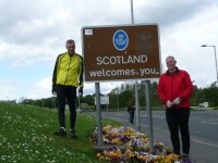
Scottish border! The first house is a lot rundown from what I remember. Picture taken it was off westwards to Annan and Dumfries. Lots of very straight, very dull roads which were hell in a galeforcd westerly wind. Stupid unnecessary loop in the NCN route at Annan to Newbie added on some pointless distance. The diversion to Powfoot is possibly worth it though the road is rough in places.

We struggled on and eventually got to Dumfries to find the only camping site marked on the map had closed down. We had to do another 5 or so miles to the next one near Shawhead which is very nice.

Afraid the day was spoiled by the wind, but as I said we’ve been lucky up to today. Better luck for tomorrow hopefully although the forecast is for rain apparently. BTW I lost about a mile or so of data due to GPS battery failure.

Distance : 74.52 miles
Time cycling : 7h40m
Ascent : 1205m
Average speed : 9.7 mph